REGIONAL SUMMARY:
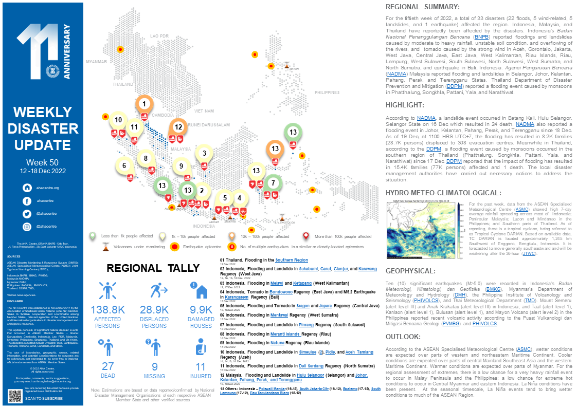
For the fiftieth week of 2022, a total of 33 disasters (22 floods, 5 wind-related, 5 landslides, and 1 earthquake) affected the region. Indonesia, Malaysia, and Thailand have reportedly been affected by the disasters. Indonesia’s Badan Nasional Penanggulangan Bencana (BNPB) reported floodings and landslides caused by moderate to heavy rainfall, unstable soil condition, and overflowing of the rivers, and tornado caused by the strong wind in Aceh, Gorontalo, Jakarta, West Java, Central Java, East Java, West Kalimantan, Riau Islands, Riau, Lampung, West Sulawesi, South Sulawesi, North Sulawesi, West Sumatra, and North Sumatra, and earthquake in Bali, Indonesia. Agensi Pengurusan Bencana (NADMA) Malaysia reported flooding and landslides in Selangor, Johor, Kelantan, Pahang, Perak, and Terengganu States. Thailand Department of Disaster Prevention and Mitigation (DDPM) reported a flooding event caused by monsoons in Phatthalung, Songkhla, Pattani, Yala, and Narathiwat.
HIGHLIGHT:
According to NADMA, a landslide event occurred in Batang Kali, Hulu Selangor, Selangor State on 16 Dec which resulted in 24 death. NADMA also reported a flooding event in Johor, Kelantan, Pahang, Perak, and Terengganu since 18 Dec. As of 19 Dec, at 1100 HRS UTC+7, the flooding has resulted in 8.2K families (28.7K persons) displaced to 308 evacuation centres. Meanwhile in Thailand, according to the DDPM, a flooding event caused by monsoons occurred in the southern region of Thailand (Phatthalung, Songkhla, Pattani, Yala, and Narathiwat) since 17 Dec. DDPM reported that the impact of flooding has resulted in 15.4K families (77K persons) affected and 1 death. The local disaster management authorities have carried out necessary actions to address the situation.
HYDRO-METEO-CLIMATOLOGICAL:
For the past week, data from the ASEAN Specialised Meteorological Centre (ASMC) showed high 7-day average rainfall spreading across most of Indonesia; Peninsular Malaysia; Luzon and Mindanao in the Philippines; and Southern parts of Thailand. As of reporting, there is a tropical cyclone, being referred to as Tropical Cyclone DARIAN. Based on available data, TC DARIAN is located approximately 1,245 km Southwest of Enggano, Bengkulu, Indonesia. It is forecasted to move generally southeastward and will be weakening after the 36-hour (JTWC).
GEOPHYSICAL:
Ten (10) significant earthquakes (M>5.0) were recorded in Indonesia’s Badan Meteorologi, Klimatologi, dan Geofisika (BMKG), Myanmar’s Department of Meteorology and Hydrology (DMH), the Philippine Institute of Volcanology and Seismology (PHIVOLCS), and Thai Meteorological Department (TMD). Mount Semeru (alert level III) and Anak Krakatau (alert level III) in Indonesia, and Taal (alert level 1), Kanlaon (alert level 1), Bulusan (alert level 1), and Mayon Volcano (alert level 2) in the Philippines reported recent volcanic activity according to the Pusat Vulkanologi dan Mitigasi Bencana Geologi (PVMBG) and PHIVOLCS.
OUTLOOK:
According to the ASEAN Specialised Meteorological Centre (ASMC), wetter conditions are expected over parts of western and northeastern Maritime Continent. Cooler conditions are expected over parts of central Mainland Southeast Asia and the western Maritime Continent. Warmer conditions are expected over parts of Myanmar. For the regional assessment of extremes, there is a low chance for a very heavy rainfall event to occur in Malay Peninsula and the Philippines; a low chance for extreme hot conditions to occur in Central Myanmar and eastern Indonesia. La Niña conditions have been present. At the seasonal timescale, La Niña events tend to bring wetter conditions to much of the ASEAN Region.
Sources:
ASEAN Disaster Monitoring & Response System (DMRS); ASEAN Specialised Meteorological Centre (ASMC); Joint Typhoon Warning Centre (JTWC);
Indonesia: BNPB, BMKG, PVMBG;
Malaysia: NADMA;
Myanmar: DMH;
Philippines: PAGASA, PHIVOLCS;
Thailand: DDPM, TMD;
Various news agencies.


