REGIONAL SUMMARY:
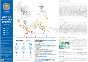
For the thirty-eighth week of 2022, a total of 33 disasters (21 floods, 5 landslides, 1 storm, and 6 wind-related) affected the region. Cambodia, Indonesia, Malaysia, the Philippines, and Thailand have reportedly been affected. Cambodia’s National Committee for Disaster Management (NCDM) reported flooding in Banteay Meanchey and Oddar Meanchey Province. Badan Nasional Penanggulangan Bencana (BNPB) reported floods, landslides, and wind-related events caused by moderate to heavy rainfall, strong wind, overflowing of the rivers, and drainage channel in Aceh, West Sumatra, Bengkulu, Lampung, Banten, West Java, Central Java, South Kalimantan, South Sulawesi, Central Sulawesi, and Southeast Sulawesi Province, Indonesia. Agensi Pengurusan Bencana Negara (NADMA) reported that flooding occurred in Johor State, Malaysia. The Philippines’ National Disaster Risk Reduction and Management Council (NDRRMC) reported flooding in Capiz (Region VI), and Tropical Cyclone NORU (local name “Karding”) caused flooding, landslides, storms, and wind-related events in several regions of the Philippines. Lastly, the Department of Disaster Prevention and Mitigation (DDPM) of Thailand reported that the Southwest Monsoon and the Low-Pressure Area caused floods which affected 18 provinces in Thailand.
HIGHLIGHT:
According to NDRRMC, from 22-24 September, Tropical Cyclone (TC) NORU (local name: Karding) developed from a Low-Pressure Area into a Tropical Storm (TS) over the Philippine Sea while moving towards Central Luzon. In the early morning of 25 September, NORU underwent a series of rapid intensifications and a period of explosive intensification and reached Super Typhoon (STY) Category. On 25 September, 1630 HRS UTC+7, NORU made its initial landfall in the vicinity of Burdeos, Quezon of the Philippines and again at 1920 HRS UTC+7 in Dingalan, Aurora of the Philippines as a TY-category cyclone. As of reporting, TC NORU has been detected based on all available data to be continuously moving west-northwestward away from Luzon towards West Philippine Sea-South China Sea-Viet Nam East Sea. According to the initial reports from the Department of Social Welfare (DSWD), as of 26 September at 0500 UTC+7, about 9.8K people were reportedly affected and 9.7K persons displaced in Regions II, III, MIMAROPA, and V of the Philippines. The AHA Centre has heightened monitoring efforts on the impacts of TC NORU and stands ready to support the member state when the need arises.
HYDRO-METEO-CLIMATOLOGICAL:
For the past week, data from the ASEAN Specialised Meteorological Centre (ASMC) showed high 7-day average rainfall spreading across Cambodia; Papua, south and western parts of Kalimantan, southwestern parts of Java, and western parts of Sumatra in Indonesia; Central Myanmar; Luzon Islands of the Philippines associated with TC NORU; and North-Central Coast and South-Central Coast of Viet Nam. As of reporting time, TC NORU is located in the NW Pacific Ocean with maximum sustained winds of 148 km/h. TC NORU is headed West at about 26 km/h and is expected to make a landfall at the Viet Nam coast and move to Lao PDR border on Wednesday, 28 Sep 2022 at 15:00 local time (ASEAN DMRS, JTWC).
GEOPHYSICAL:
Eight (8) significant earthquakes (M>5.0) were recorded in the region by Indonesia’s Badan Meteorologi, Klimatologi, dan Geofisika (BMKG) and Philippine Institute of Volcanology and Seismology (PHIVOLCS). Mount Semeru (alert level III) in Indonesia, and Taal (alert level 1), Mayon (alert level 1), and Kanlaon Volcano (alert level 1) in the Philippines reported recent volcanic activity according to the Pusat Vulkanologi dan Mitigasi Bencana Geologi (PVMBG) and PHIVOLCS.
OUTLOOK:
According to the ASEAN Specialised Meteorological Centre (ASMC), for the coming week, wetter conditions are expected over most of the southern ASEAN region. Drier conditions are expected over much of Mainland Southeast Asia. Warmer conditions are expected over parts of the southeastern Maritime Continent. For the regional assessment of extremes, there is a small increase in chance for extreme hot conditions to occur in southeastern Indonesia. La Niña conditions have been present. At the seasonal timescale, La Niña events tend to bring wetter conditions to much of the ASEAN region. A negative Indian Ocean Dipole (IOD) is now established. Negative IOD tends to bring wetter conditions to much of the southern ASEAN region.
Sources:
ASEAN Disaster Monitoring & Response System (DMRS); ASEAN Specialised Meteorological Centre (ASMC); Joint Typhoon Warning Centre (JTWC);
Indonesia: BNPB, BMKG, PVMBG;
Malaysia: NADMA;
Philippines: NDRRMC, PAGASA, PHIVOLCS, DSWD;
Thailand: DDPM;
Various news agencies.


