FLASH UPDATE #1 – Tropical Cyclone JELAWAT (Kabayan)
Country under monitoring: Philippines
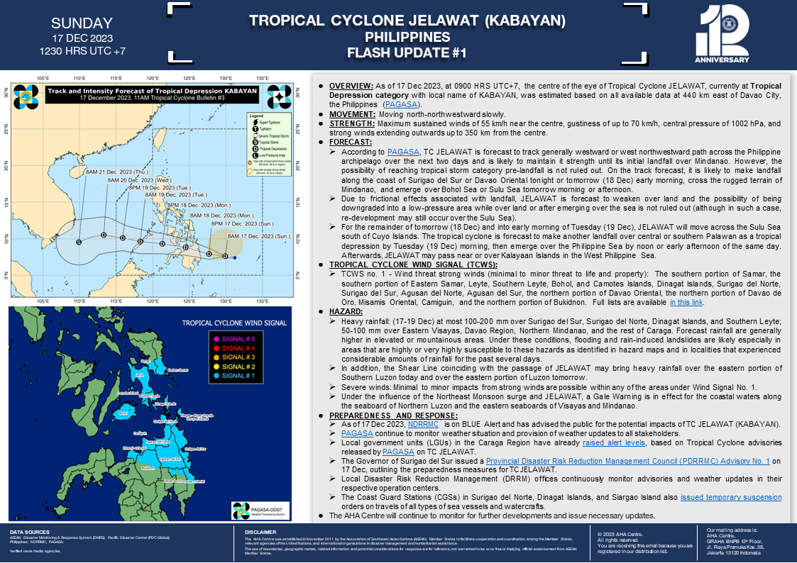
OVERVIEW: As of 17 Dec 2023, at 0900 HRS UTC+7, the centre of the eye of Tropical Cyclone JELAWAT, currently at Tropical Depression category with local name of KABAYAN, was estimated based on all available data at 440 km east of Davao City, the Philippines (PAGASA).
MOVEMENT: Moving north-northwestward slowly.
STRENGTH: Maximum sustained winds of 55 km/h near the centre, gustiness of up to 70 km/h, central pressure of 1002 hPa, and strong winds extending outwards up to 350 km from the centre.
FORECAST:
- According to PAGASA, TC JELAWAT is forecast to track generally westward or west northwestward path across the Philippine archipelago over the next two days and is likely to maintain it strength until its initial landfall over Mindanao. However, the possibility of reaching tropical storm category pre-landfall is not ruled out. On the track forecast, it is likely to make landfall along the coast of Surigao del Sur or Davao Oriental tonight or tomorrow (18 Dec) early morning, cross the rugged terrain of Mindanao, and emerge over Bohol Sea or Sulu Sea tomorrow morning or afternoon.
- Due to frictional effects associated with landfall, JELAWAT is forecast to weaken over land and the possibility of being downgraded into a low-pressure area while over land or after emerging over the sea is not ruled out (although in such a case, re-development may still occur over the Sulu Sea).
- For the remainder of tomorrow (18 Dec) and into early morning of Tuesday (19 Dec), JELAWAT will move across the Sulu Sea south of Cuyo Islands. The tropical cyclone is forecast to make another landfall over central or southern Palawan as a tropical depression by Tuesday (19 Dec) morning, then emerge over the Philippine Sea by noon or early afternoon of the same day. Afterwards, JELAWAT may pass near or over Kalayaan Islands in the West Philippine Sea.
TROPICAL CYCLONE WIND SIGNAL (TCWS): TCWS no. 1 – Wind threat strong winds (minimal to minor threat to life and property): The southern portion of Samar, the southern portion of Eastern Samar, Leyte, Southern Leyte, Bohol, and Camotes Islands, Dinagat Islands, Surigao del Norte, Surigao del Sur, Agusan del Norte, Agusan del Sur, the northern portion of Davao Oriental, the northern portion of Davao de Oro, Misamis Oriental, Camiguin, and the northern portion of Bukidnon. Full lists are available in this link.
HAZARD:
- Heavy rainfall: (17-19 Dec) at most 100-200 mm over Surigao del Sur, Surigao del Norte, Dinagat Islands, and Southern Leyte; 50-100 mm over Eastern Visayas, Davao Region, Northern Mindanao, and the rest of Caraga. Forecast rainfall are generally higher in elevated or mountainous areas. Under these conditions, flooding and rain-induced landslides are likely especially in areas that are highly or very highly susceptible to these hazards as identified in hazard maps and in localities that experienced considerable amounts of rainfall for the past several days.
- In addition, the Shear Line coinciding with the passage of JELAWAT may bring heavy rainfall over the eastern portion of Southern Luzon today and over the eastern portion of Luzon tomorrow.
- Severe winds: Minimal to minor impacts from strong winds are possible within any of the areas under Wind Signal No. 1.
- Under the influence of the Northeast Monsoon surge and JELAWAT, a Gale Warning is in effect for the coastal waters along the seaboard of Northern Luzon and the eastern seaboards of Visayas and Mindanao.
PREPAREDNESS AND RESPONSE:
- As of 17 Dec 2023, NDRRMC is on BLUE Alert and has advised the public for the potential impacts of TC JELAWAT (KABAYAN).
- PAGASA continues to monitor weather situation and provision of weather updates to all stakeholders.
- Local government units (LGUs) in the Caraga Region have already raised alert levels, based on Tropical Cyclone advisories released by PAGASA on TC JELAWAT.
- The Governor of Surigao del Sur issued a Provincial Disaster Risk Reduction Management Council (PDRRMC) Advisory No. 1 on 17 Dec, outlining the preparedness measures for TC JELAWAT.
- Local Disaster Risk Reduction Management (DRRM) offices continuously monitor advisories and weather updates in their respective operation centers.
- The Coast Guard Stations (CGSs) in Surigao del Norte, Dinagat Islands, and Siargao Island also issued temporary suspension orders on travels of all types of sea vessels and watercrafts.
The AHA Centre will continue to monitor for further developments and issue necessary updates.
DATA SOURCES:
ASEAN Disaster Monitoring & Response System (DMRS); Pacific Disaster Center (PDC Global);
Philippines: NDRRMC, PAGASA;
Verified news media agencies.


