FLASH UPDATE #2 – Tropical Cyclone SANBA
Country under monitoring: Viet Nam
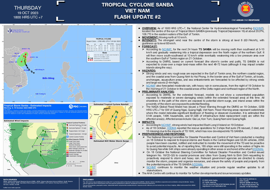
OVERVIEW: As of 1600 HRS UTC+7, the National Center for Hydrometeorological Forecasting (NCHMF), located the centre of the eye of Tropical Storm SANBA (previously Tropical Depression 16) at about 20.3°N, 108.7°E in the eastern waters of the Gulf of Tonkin.
MOVEMENT: Moving north at 10 km/h.
INTENSITY: The strongest wind near the centre of the storm is strong at level 8 (62-74km/h), with gustiness up to level 83 km/h.
FORECAST:
- According to NCHMF, for the next 24 hours TS SANBA will be moving north then southwest at 5-10 km/h and gradually weakening into a tropical depression over the North region of the northern Gulf. It will then move south-southwest at 10 km/h while eventually weakening into a low pressure area over the southern Gulf of Tonkin region on 21 October.
- According to DMRS, based on current forecast (the storm’s centre and path), TS SANBA is not expected to cross-over a major land-mass within the next 48-72 hours (although it may impact smaller islands along the way).
HAZARDS:
- Strong winds and very rough seas are expected in the Gulf of Tonkin area, the northern coastal region, and the coastal area from Quang Ninh to Hai Phong. In the border area of the Gulf of Tonkin, all boats, anchorages, aquaculture areas, and sea embankments are forecasted to be affected by strong winds and large waves (2-4m high).
- NCHMF also forecasted moderate rain, with heavy rain in some places, from the night of 19 October to the morning of 21 October in the coastal areas of the Delta region and northeast region of the North.
PRELIMINARY ANALYSIS:
- According to DMRS, for the extended forecast, models do not show a concentrated population exposed to moderate or severe damaging winds (within the extended forecast area) at this time. All shorelines in the path of the storm are exposed to potential storm surge, and inland areas within the proximity of the storm are exposed to potential flooding.
- The NASA Global Flood Model has issued a Flood Warning through the DMRS on 19 October, 0233 HRS UTC+7 for SW of Quang Ngai, Qu?ng Ngãi, Viet Nam. Flood Warning areas represent watersheds where the model indicates significant likelihood of flooding or observed inundation. It is estimated that 514K people, 149K households, and $1.02B of infrastructure (total replacement cost) are within the affected area(s). Affected areas include: Gia Lai, Kon Tum, Quang Nam and Quang Ngãi.
IMPACTS:
- According to NCHMF, strong winds had impacted Bach Long Vi Island on 19 October.
- As of 18 October, VDDMA reported the rescue operations for 2 ships that sunk (78 rescued, 2 died, and 13 missing) due to the impacts of TD 16W, which has now developed into TS SANBA.
PREPAREDNESS AND RESPONSE:
- The National Steering Committee for Disaster Prevention and Control of Viet Nam conducted a meeting on 18 October to respond to tropical storms and floods in the Central Region and 53.3K vehicles, 226K people have been counted, notified and instructed to monitor the movement of the TD and be proactive to avoid potential impacts. As of reporting time, 185 ships were still operating in the waters of Nghe An to Quang Nai while 54K ships were already operating in other areas or anchored at the wharf (VDDMA).
- On 18 October the National Steering Committee for Natural Disaster Prevention and Control issued telegram No. 16/CD-QG to coastal provinces and cities from Quang Ninh to Binh Dinh requesting to proactively respond to storm and heavy rain. Relevant government agencies are directed to closely monitor the storm, prepare and organize resources, and ensure the safety of people and property from the potential impacts of the TS SANBA (VDDMA).
- NCHMF continues to monitor the weather situation and provide regular weather updates to all stakeholders.
The AHA Centre will continue to monitor for further developments and issue necessary updates.
DATA SOURCES:
ASEAN Disaster Monitoring & Response System (DMRS);
Viet Nam: VDDMA, NCHMF;
Verified news media agencies.


